Situation Maps: The Burma Army’s Authority Deteriorates as it Struggles to Maintain Control within the Country

Situation Maps: The Burma Army’s Authority Deteriorates as it Struggles to Maintain Control within the Country
24 April 2022
Burma
The Burma Army’s authority within the country has decreased significantly since the Burma military staged a coup on February 1, 2021, against the National League for Democracy (NLD)-led, democratically-elected government. After the coup, NLD representatives, along with many other citizens, helped form the National Unity Government (NUG) to counter the junta’s attempts to control the country. Many ethnic armed groups who have been standing for freedom for over 73 years are allied loosely with the NUG and People’s Defense Forces (PDFs) in this struggle for a democratic and federal system of government in Burma. Some ethnic groups maintain a ceasefire with the regime, while a few ethnic groups serve as proxy forces for the dictators.
Post-coup, the violence in Burma has increased tenfold, killing thousands of people, and displacing over three million. The Burma military is attacking at a speed and a force we have not seen before. The military has been responsible for the vast majority of targeted violence against civilians, and it continues to kill, steal, and destroy with impunity. These two maps represent FBR’s assessment of the situation in Burma. They show that most of Burma was under the Burma military central authority prior to the coup of 1 February 2021; but now, over two years later, the pro-democracy movement, led by ethnic armed groups and mostly Burman PDFs, have authority over much of the country or have contested the regime’s authority. The dictator’s army and militias still control all major cities, and most border crossings, sea and air lanes; however, their authority is severely degraded outside these areas.
Situation Maps:
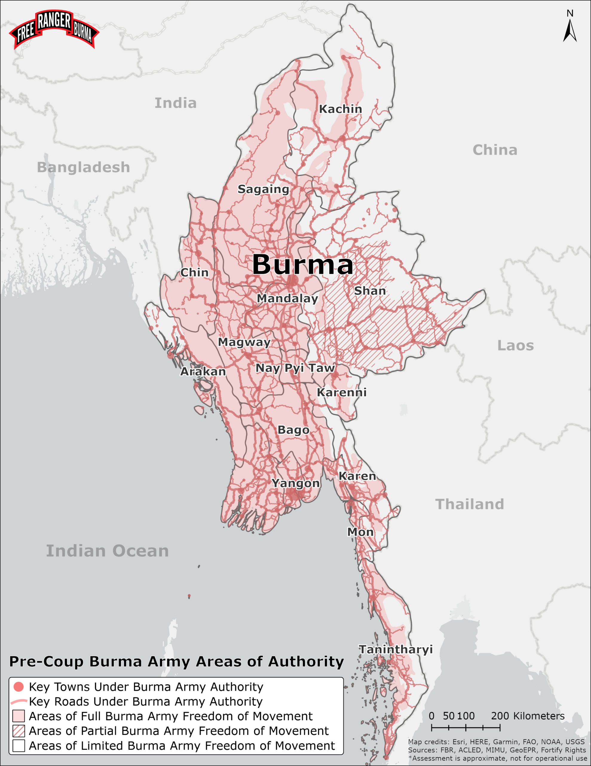
Map 1: Pre-Coup Burma Army Areas of Authority
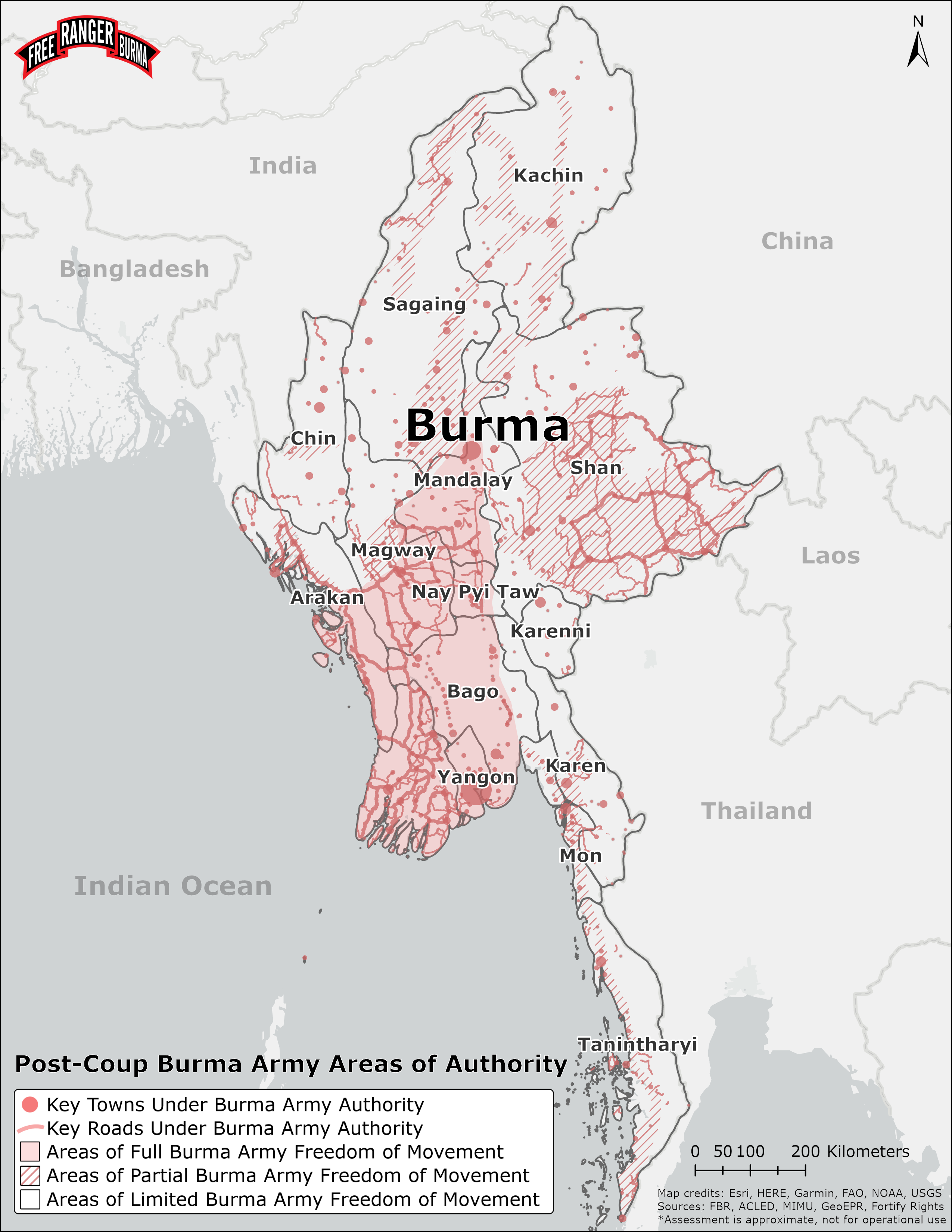
Map 2: Post-Coup Burma Army Areas of Authority
FBR characterizes “areas of authority” as spaces where the Burma Army generally controls the population and infrastructure without serious competition. The conflict analysis used in this assessment was primarily derived from the reports of FBR relief teams on the ground as well as data from the Armed Conflict Location Event Database (ACLED), which is publicly available.
Here is a summary of the map features from FBR’s assessment:
- The red dots on the maps represent the key towns of Burma with predominant Burma Army authority. Few towns have exchanged hands between the Burma Army and resistance since the coup started.
- The red-filled lines on the maps represent the key roads that Burma Army exercises authority over. The Burma Army can and often does operate on roads that it does not have authority over; however, these movements require an excessive amount of troops to guarantee mission security and success.
- The red-filled areas represent spaces where the Burma Army generally has freedom of movement to conduct operations in the areas surrounding key towns and roads.
- The red-hashed areas represent spaces where the Burma Army has partial freedom of movement.
- Areas with no fill indicate spaces where the Burma Army has very limited freedom of movement.
Please pray with us for Burma, first, that the Burma military would have a change of heart or would be stopped. Second, please pray that God’s love would fill everyone’s hearts to work together to build a new Burma that is free and fair for all.
Map Sources
- Conflict analysis derived from FBR relief teams on the ground as well as data from the “Armed Conflict Location & Event Data Project (ACLED); http://www.acleddata.com.” and “Fortify Rights: https://www.fortifyrights.org/.”
- Administrative data is from “Myanmar Information Management Unit (MIMU); https://themimu.info/.”
- Ethnic data is from “ETHzürich; https://icr.ethz.ch/data/epr/geoepr/.”
View the original